
Today’s Post follows the route taken by Jacques Balmat and Dr Michel Gabriel Paccard on the first day of their two-day first ascent of Mont Blanc on 7-8 August 1786. The route starts from the commune of Les Bossons about 3Kms down-valley from Chamonix and climbs what is known as the Montagne de la Côte – a prominent ridge that separates the Glacier des Bossons from the Glacier du Taconnaz – up to La Jonction at the top of the ridge.
This ridge can be very clearly seen from the Aiguilles Rouges on the North side of the Chamonix valley (accessible by cable car from Chamonix).
Click any image in this post to see a higher quality enlargement.

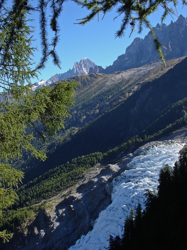
View from Aiguilles Rouge. Montagne de la Cote is the dark finger of rock bottom centre of frame
It is also a prominent feature seen from Chamonix itself.

Bossons Glacier cascading centre frame to Rt corner with the Montagne de la Cote beyond it.
It is possible to shorten this walk by taking the Télésiège (chairlift) from near Les Bossons to the Chalet du Glacier des Bossons where you can sip a beer or a glass of wine while admiring the dramatic views over the tongue of the Bossons Glacier. But for the purist the walk from the valley floor although long (4-5hrs for approx 5,100ft ascent) is well worth the effort. The path is not difficult to follow although in places it crosses steep terrain and requires a head for heights.
Caution: Do not attempt this climb in bad weather, and especially not in winter unless you are properly equipped (snowshoes, crampons and ice axe – for self arrest – required) and have experience of walking steep mountain trails under winter conditions. Even in summer carry extra clothing and be prepared to turn back if the weather deteriorates. Always leave information with family, friends or your hotel indicating your itinerary and likely return time.
View from near Chalet du Glacier des Bossons over the Bossons Glacier to the Chamonix Aiguilles beyond.
Aig Verte centre background

Higher up, View across Bossons Glacier to Aiguille du Midi
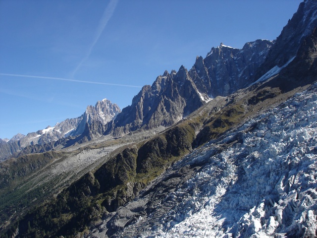
For the first two hours the path zig-zags incessantly up through forested terrain before emerging onto initially rough grassy hillside and finally stony ground. There are no significant problems for the experienced walker with stamina and a good pair of legs. But do make sure you reserve this wild walk for a perfect day – it’s a long way to go with no view from the top and please read the cautionary note earlier in this article about it. At times the path follows a line to the left of the ridge, at others it switches to the right side giving commanding views of the Taconnaz glacier and the Dome du Gouter.

View up the Taconnaz Glacier to the Dome du Gouter and Aiguille du Gouter
Shortly before you reach the top of the ridge you will pass two huge boulders and there you will find an important inscription.

The site of Balmat and Paccard’s bivouac
This is the concrete evidence that you have followed the path of Balmat and Paccard and that this is the precise spot where they bivouacked on 7 August, on the night before their successful summit climb. As with all climbers I imagine that their thoughts that night were a mixture of anxiety about the difficulties they would face the following day and the excitement that they might finally succeed in conquering this mountain.
Before we view the scene from this remarkable point let’s return to the very first image in this post. On summit day, the two climbers left their camp at the top of the Montange de la Cote and crossed La Jonction (the Junction), a convoluted crevassed area where glaciers merge and separate before forming the Taconnaz and Bossons glaciers that both descend steeply to towards the valley floor. Having negotiated La Jonction they moved up the heavily crevassed slopes beyond climbing more or less straight up through the frame to Le Grand Plateau at which point they chose to climb diagonally up and left following the red line on the image below up a ramp that has become known as the Ancien Passage before tracking back right up easier snow slopes to the summit (snow dome below the word ‘passage’). Enlarge image for a clearer view

The panorama from the top of the Montagne de la Cote is breathtaking in whichever direction you choose to look. Looking down to the tiny speck of Chamonix in the Arve valley over 5,000feet below gives you a real sense of height.

View down to Chamonix
Turn through 180 degrees and look out down the valley past Les Houches in the direction of Geneva

View down Chamonix valley towards Geneva
And now to the breath-taking panorama. Sweep your eyes across the extraordinary sight above you. Firstly up valley following the line of the Chamonix Aiguilles to the Aiguille Verte in the far distance. The intermediate lift station of the Aig du Midi lift can be seen sitting on a grassy ridge mid height in the frame and close to the left edge of the frame.
The Chamonix Aiguilles, Aig Verte in the distance
Move your eyes up from that last frame to the imposing bulk of the Aiguille du Midi.

Move your gaze further right and you look straight up, as Balmat and Paccard would have done, through the chaos of La Jonction past those two rocky black fins, on and on up, everything compressed and distorted by the distance to the summit of Mont Blanc seen just left of the further of the two rock fins. How could there possibly be a route through there?

The view of La Jonction and the route to the summit.
Look further right over the Glacier du Taconnaz with the Aiguille du Gouter above it.

Glacier du Taconnaz, Aiguille du Gouter
And then in one sweep see the panorama – this next image is a three shot panorama stretching from Mont Blanc du Tacul to the Aiguille du Gouter. This is without doubt one of the most impressive views of the Mont Blanc massif, and all the more dramatic because of the closeness one is to the glaciated terrain.
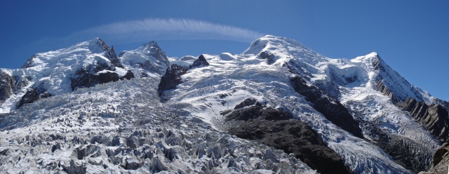
From Lt: MB du Tacul, Mont Maudit, Mont Blanc (diminutive because of its distance), Dome du Gouter, Aiguille du Gouter.
In the foreground the chaotic jumble of La Jonction
I was indeed there.

The Author in 2005. Aiguille du Midi behind
These images were taken with my first digital compact in 2005. Ten years earlier in 1995 I guided my son, then aged 17 to the summit of Mont Blanc, Our route involved taking the cable car to the intermediate lift station (mentioned a few images above) from where we tracked horizontally towards the left edge of La Jonction negotiating heavily crevassed ground before climbing up to Les Grands Mulets Refuge sited on the first of the two Rock Fins – see red pointer marking Refuge in the next image.

Another view up the line of ascent with the Grands Mulet Refuge arrowed.
The following day we set out at 1am to climb to the summit, following Balmat and Paccard’s route as far as the Grand Plateau where nowadays the route turns right to reach the Col du Dôme and then proceeds up the Bosses Ridge to the summit. We reached the summit at about 9am. Retracing our steps back down the same route through the convoluted maze of Crevasses and back to the Cable Car station took us until about 6pm. What a day! A day neither of us will ever forget and a huge privilege to do it together. And a special thanks to my dear wife for allowing the pair of us to make this climb.
Due to climate change, and the deterioration in the glaciers, the Grands Mulets Route is not often climbed now in summer, although remains climbable in Spring when the crevasses are well covered and snow bridges solid and reliable.
If you missed the Post about the fascinating story behind the first ascent of Mont Blanc, click here to go to it.


I am not sure whether to be more impresses by the photographs or by the climb. But I can’t actually see the climb so the photographs win. Congratulations, and specially for adding the camera to the weight you were carrying.
Where next?
LikeLike
Thanks very much for commenting Sally. Thankfully the camera was light.
LikeLike
Great photos and commentary. It looks cold but everyone is wearing summer shorts and short sleeve shirts. ???
LikeLike
Thanks Ken. The top of this ridge is about 2,500M (8150ft approx). On a summer’s day, like the one I had that day, it’s still pleasantly warm. But step out onto the ice and it will feel cooler and of course as you go higher it will progressively get colder. But I have been at 13,000ft and felt warm enough to be in a base layer and a shirt.
LikeLike
These are terrific Andy. Your images and documentation really brings life to the trek.
LikeLike
Thanks Len – I’ve really enjoyed taking a look at these images again myself. This is an extraordinary viewpoint. A camera can never really do justice to panoramas like these.
LikeLike
Been there love every shot that evokes the memories !!!!! Thank you! 🙂
LikeLike
Thanks so much Pawel. So pleased to hear that you have been to this spot too. I don’t think it is as well walked as it really should be. It’s an amazing vantage point. Hope you had a good day for it like I did.
LikeLike
Well I probably wasn’t in exactly same place but we were in the same area and I can recognize some places. 🙂 Which is nice to bring the memories back while we were climbing up the Mount Blanc 😉
LikeLike
Another great post and stunning photos, thanks Andy.
LikeLike
Many thanks Mark. Glad you liked the images – just a 4mega-pixel Sony compact – they turned out OK!
LikeLike
superb post – the photos are excellent (I am almost out of breath thinking about the climb) and the narrative is just how it should be – informative and very interesting. A perfect mornings read!
LikeLike
Thank you so much SP. Glad you enjoyed it.
LikeLike
I almost prefer to hike between high mountains, but these photos are wonderful.
LikeLike
Thanks Bente. There is a lot of truth in what you say. Some of the best walks don’t actually involve climbing to the top of a mountain but just moving among them with the high peaks dominating the horizon. It’s also a lot less hard work too!
LikeLike
Just terrific Andy, what a fabulous set of photographs!! Love reading about all this, too, it gives me a chance to visit a place I’ve never been to. Wonderful work, in every aspect of the term!
LikeLike
Many thanks for commenting Toad. Climbing and walking in the Alps can be hard work but so rewarding too when you get to see places like this.
LikeLike
Wow spectacular Andy. I would love to hike through these mountains. A photograph is supposed to make you want to jump right in and be in that location and yours are doing just that.
LikeLike
Thanks very much Edith
LikeLike
What a terrific post – the images are wonderful and you tell the story so well. It must be very satisfying to follow the footsteps of those pioneers and to get some sense of what they must have experienced so long ago.
LikeLike
Thanks very much. I was blessed with a beautiful day and a little Sony compact really produced some wonderful shots that needed virtually no tweaking in Photoshop.
LikeLike
How wonderful for you and your son…and beautiful photos, too, Andy…what views from up there….
LikeLike
Thanks Scott. This is a top notch place to walk to. And for obvious reasons it has a lot of personal significance. In the New Year I must see is I can scan my images from our ascent and run a Post about them
LikeLike
You’re very welcome…I will look forward to that post, Andy….
It sure has been a pleasure visiting with you over the months. I hope you and your family have a great holiday.
LikeLike